This site contains affiliate links, so I might receive a commission if you click and buy something. It doesn´t cost you any extra, but I could treat myself to some extra snacks to keep me going on my outdoor adventures! Read more in my Privacy Policy
The main beach
“EmbalseCrevillente” is a lesser-known reservoir situated in the south of the Costa Blanca.
It is located north-east of Crevillente town, but is also fairly close to the towns of Elche and Aspe.
It is a great place to visit all year round and has two notable areas, that are easily accessible, the nothern part, and the southern part…
The northern partof the Embalse Crevillente is perfect for:
Short hikes near the reservoir
Longer hikes into the mountains nearby
Relaxing on the “beach” and swimming in the reservoir (for people and dogs)
Turtle-spotting
Enjoying nature.
.
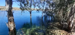
If you love swimming in a crystal clear water in a natural environment, then you
Unfortunately, it is not possible to walk all the way around the Embalse Crevillente reservoir (I have tried!)
It ispossible to cycle around the reservoir. However, the roads are quite far from the water, and it is necessary to cycle on the main N-325 road to pass around the southeastern edge of the Embalse Crevillente.
A mountain bike (rather than a road bike) would help to reduce the distance on the main road, but it is not possible to avoid it altogether.
If you like the Embalse Crevillent, then you will love the Embalse Amadorio near Villajoyosa. You can cycle all the way around this reservoir, and there is a mountain biking area too. It has several “beaches” for relaxing and “accessible” areas.
More hiking and exploring north of the Embalse Crevillente
Natural pools in the mountains
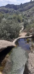
There is a series of small natural pools situated in the Sierra de Crevillente mountains. The first is called the “Charca de los Sapos”
This translates to “pond of the toads” and it lives up to its name because I met some toads there when I visited.
To access this location, there is a hiking path that begins on the roadhere. If you look at the satellite map, you can see it clearly leading to the first natural pool.
Then you can follow this hike to see the other natural pools.
While passing, I noticed an information board indicating some florahere.
TOP TIP for Explorers: Go and check it out!
To access it, you can parkhereand walk 15 minutes up the road.
(Google Maps™ mapping service is a trademark of Google LLC and this blog is not
endorsed by or affiliated with Google in any way)
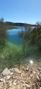
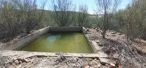
Beaches and Swimming (Embalse Crevillente north)
Along the northern part of the Embalse Crevillente, there are several “beaches”.
There are some signs along the road which state that swimming is prohibited, but the water is incredibly inviting, and families, friends and dog owners have visited this area to relax and swim for years.
They are about a very short walk (5-10 minutes) from the relevant parking area.
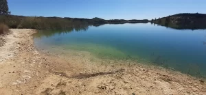
The beaches are rocky, and you can walk into the water from the shore until it is deep enough to swim.
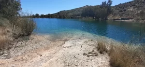
The main beach is the longest and widest, and (if I remember correctly) it is sandy.
It is very close to the dedicated car park, with a hiking path right opposite the car park that leads directly to it. This is the busiest area.
The main beach
Beach 1: Sloped track
There is (what appears to be) a boat entrance to the Embalse Crevillente here. Basically it is a sloped “track” leading down to the water from the road, although vehicle access it prevented by a chain.
You can park in the dedicated car park and walk here. The ground near the water is very slightly sloped rock, and the area is suitable for one family or group of friends.
Sloped track beach
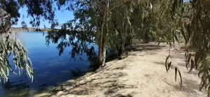
Beach 3: Forest area
There is a “forest” area, which is great if you want some shade from the trees in the summer months. It is a flat area with hard ground where a few families/groups could easily set up for a picnic.
You can do the northern hiking route from here or simply go and explore further along the land.
There is parking area that would accommodate 2-4 cars here, but take care because there is quite a big curb to enter the parking area. However, I drove into the area right at the edge where it is slightly smaller and my car was fine.
Forest beach
Beach 4: Secret beach
My favourite (very small) beach area is here, and further along this section of the reservoir, because other people don´t go there!
To access it, you need to step over the barrier somewhere here just before the house. Enjoy!
Regardless of which beach you visit, I recommend wearing footwear that is suitable for rough terrain as well as water activities, for better comfort and safety.
I would not recommend swimming in the southern part where the dam is located as there is running water that enters here, and the shore is much steeper and rockier.
Water enters near the dam
Turtle spotting (Embalse Crevillente north)
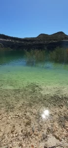
When I visited the northern part of the Embalse Crevillente in March, I saw lots of very big turtles (about a foot long!), as well as some smaller ones.
I saw them:
During the northern hiking route. For example, after the first peninsula, and around the path to the “island” when you have water at both sides of you.
I visited to southern part of the Embalse Crevillente in November, there were no turtles to be seen (and I was searching for them!)
If you want to see them, I recommend that you:
Stay as quiet as possible as you approach the water
Look on branches and rocks that are sticking out of the water.
Happy turtle hunting!
Big turtles live in here (approach quietly)
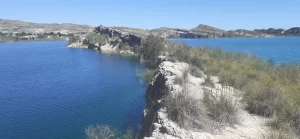
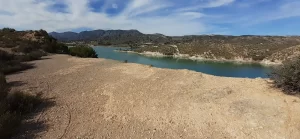
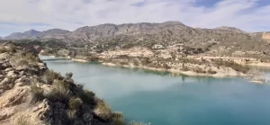
Hiking Route 2: South of the Embalse Crevillente
This is a 6km hiking route, which starts from an easily accessible location near the main road.
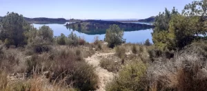
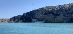
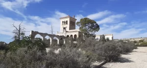
First, the route passes through the countryside where you can explore the “Villa Malta” ruin, before reaching the dam.
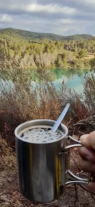
After the dam, there is a great unofficial viewing point. It is a big flat area situated but raised up from the road. Therefore, it is the perfect place to enjoy panoramic vews over the Embalse Crevillente, and to have a picnic!
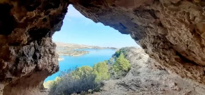
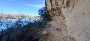
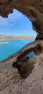
On both sides of the dam, the sandy cliffs with caves overlooking the water offer opportunities to explore.
"Villa Malta" ruin
Viewing point and picnic area
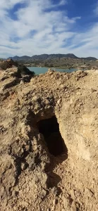
TOP TIP for Adventurers:
To the right of the dam, you can…
Scramble up to a little cave for a view and a sit down
Climb down throughthis hole and down a steep slope to the shore
For a more accessible route, you can park here and:
Walk up the concrete road on the left to reach the dam
Go through the pedestrian access gate ahead and walk along the wide gravel track that turns to the right.
.
Fishermen also use this parking area, and the route leading to the right because they fish right at the end of this area.
View from the south
Who is it suitable for?
This is suitable for people with mobility impairments because the terrain is largely free from hazards.
However, it might not be suitable for wheelchair users, because there is sometimes a chain prohibiting vehicle across to the dam road (not seen in the image below), and there are two gates which allow pedestrian access (one is shown in the image below, and the other is close to the dam). I didn´t pay attention to the widths of these access point, in relation to the size of a wheelchair, when I visited.
(Google Maps™ mapping service is a trademark of Google LLC and this blog is not
endorsed by or affiliated with Google in any way)
TOP TIP for Explorers:
The wide gravel track that leads to the right appears to continue around the reservoir.
This is one part that I haven´t yet explored, so go and see what you can find!
Want to explore more in this area?
If you are in the Crevillente area, then you could also:
Make sure that you are prepared with this essential outdoor gear for your mountain adventures, such as: Hydration systems, Mobile phone chargers, Headtorches, Water filters, Backpacks, Footwear and a multi-adventure guidebook for your mountain adventures in the Costa Blanca.