This site contains affiliate links, so I might receive a commission if you click and buy something. It doesn´t cost you any extra, but I could treat myself to some extra snacks to keep me going on my outdoor adventures! Read more in my Privacy Policy
If you are looking for a 3-hour mountain hiking challenge to work on both your cardio and your muscles, then you are in the right place!
He we have 3 mountain hiking routes all located south/south-west of the town of Jalón.
They all have some wild paths to go up, steep and rocky sections, and a little optional scrambling along the way.
However, the return paths allow you to relax after you have put in the hard work.
These Jalón mountain hiking routes are all slightly different, and demanding in their own ways.
For example, Hike 2 has the least elevation, but also the longest distance, so all of the routes have in a similar level of difficulty in the end.
The distances range from 4.5km-7.9km.
However, Hike 3 can be reduced (to just a 1.6km linear hike) if you still want to tackle the highest peak of the three mountain hiking routes, but via a muchshorter route.
All of these hiking routes are graded as moderate. However, they may be regarded as difficult for people who are not used to mountain hiking in Spain.
These Jalón hikes are suitable for seasoned hikers who are accustomed to uneven terrain and steep inclines.
They are not suitable for people with a low level of fitness (although hike 3 has a much shorter option for those who want to try mountain hiking for the first time).
If you are a person who gets nervous when you are not walking on a clearly defined path, then these Jalón mountain hiking routes are not for you, because all three have unmarked routes to ascend.
All 3 of these routes are best avoided in the hottest months (e.g. July and August), since there is no shade across the tops of these Jalón mountains.
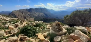
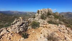
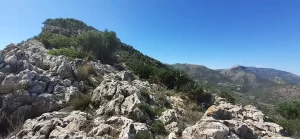
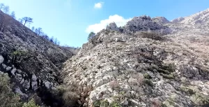
Rocky section between Penyal de la Mica towards Alt de l´Ample
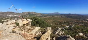
Jalón mountain hiking route 1: Penyal de la Mica (488m) and Alt de l´Ample (600m)
A short but challenging mountain hiking route on an initially quite steep ascent over wild terrain reaching two peaks (up to 600m), with a touch of scrambling for the more adventurous.
View from Penyal de la Mica towards Alt de l´Ample
Route Summary
The Penyal de la Mica and Alt de l´Ample mountain hiking route in Jalón consists of:
Distance: 5 km
Time:3 hours
Difficulty: Moderate
Type: Circular (anticlockwise)
Elevation: 362 metres
Alternative options: Longer routes possible
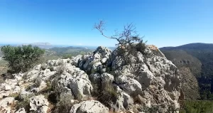
Penyal de la Mica summit
Route Description
This is a great mountain hiking route starting on a fairly wild and very steep path that goes up through the trees, then bushes, which you can find by following the red dots painted on the rocks.
This 1kmincline, will lead you up to the first peak, Penyal de la Mica that has a flag pole on it, where you are rewarded by an awesomeview towards Jalón and beyond.
There is then a steady 1.1km incline up to the next peak, with a few little rocky outcrops which you could scramble over, or go around.
At the second peak, Alt de l´Ample, you can enjoy 360-degree panoramic views. This area is quite large and flat, a perfect space for a rest on the grass while enjoying the scenery.
To descend from the peak, you can choose between a super-short scrambly section (literally a few metres to clamber down) or you can follow the slightly wild but well-trodden detour that I took on my mountain hiking route.
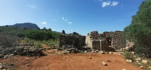
Then you can then take pleasure in the long, steady, easier path down through the prettyvalley on the far side, that passes a couple of ruins, and takes you through a nice woodland area before returning to the car park.
You can park here at this sandy area next to the road.
This is a definitely a public parking place, and it is used by hikers, although it may appear to belong to the house opposite.
When I visited for the first time, I thought that I couldn´t park there, because there was an owner standing at the gate with several dogs barking, and somebody picking olives on the land nearby. However, I spoke to him and he confirmed that anybody can park there.
To begin this mountain hiking route, cross over the main road and walk up the side road just before the bridge.
(Google Maps™ mapping service is a trademark of Google LLC and this blog is not endorsed by or affiliated with Google in any way)
Alternative options
Shorter route (Scrambling option)
Just after Alt de l´Ample there is a cairn, and a scrambling routehereto lead you down to the paths that you can see below.
If you do the scramble, then this mountain hiking route will be shorter in distance.
This route down is not very obvious from the top. In fact, I had to search for it.
I didn´t scramble down it (because I had a big dog with me). However, I did go and have a look from the bottom, which you can see on my hiking route.
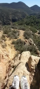
Alt de l´Ample scramble (from above)
Alt de l´Ample scramble (from below)
Want to discover SECRET WILD SWIMMING spots in SELLA?
If you want to start this mountain hiking route from closer to Jalón town, there is a car park here, which would give you an extra 1.9 km walking on a (quiet) road.
This carpark can accommodate about 15 vehicles.
There is another (closer) car park here, (on Camí del Cementerí near Jalón town) which would give you an extra 1.5 km walking on a (quiet) road.
This is a big car park and there are always spaces available.
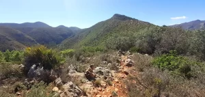
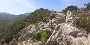
Rocky ridge path from Penyal de la Mica between Alt de l´Ample
TOP TIPS for this route
There is no phone signal down in the valley
Follow the main zigzag path and don´t be tempted to short-cut on the way down. The stepped farmland is deceiving, and you will end up going away from the path
There are lots of mosquitos in the forest area during warmer seasons
Watch out for mountain bikes on the lower forest path! I came across several during this route
You cannot drive on Camí del Cementerí in Jalón between 8am-9.30am and 30pm-2.30pm on weekdays (due to school operations)
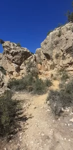
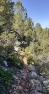
Forest path below Penyal de la Mica
The next mountain hiking route covers more distance (an additional 2.4km) than this route, but it takes about the same amount of time due to the easier terrain….
Jalón mountain hiking route 2: Serra de la Devesa (458m)
A mountain hiking route perfect for both hiking and trail running, with the majority being on goodterrain with easy-to-follow paths that pass through delightful surroundings. But you have to get past the initial rocky wild terrain to meet the official path!
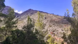
Serra de la Devesa
Route Summary
The Serra de la Devesa mountain hiking route in Jalón consists of:
Distance:9 km
Time: 3 hours
Difficulty:Moderate
Type: Circular
Elevation: 322 metres
Alternative options: Longer routes possible
Rocky path up to Serra de la Devesa
Route Description
The first 0.5 km of this mountain hiking route is the most difficult part.
It begins with a short but steep incline from the road.
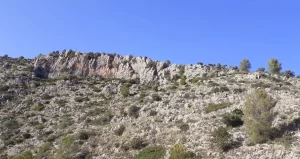
The path then becomes clearer and starts to head around the mountain, but rather that follow it, this route turns left going straight up through a steeper rocky section with just a touch of scrambling if you follow the edge to the left.
The following 1.3 km continues on the unofficial path along the top of the wide ridge. It is rocky in parts, and some small sections are overgrown with bushes/trees to manoeuvre through. The upper part consists of old step-farming land, which is easy to ascend to reach the top.
This “peak” (404 metres high) gives you fantastic views over Jalón and the other towns below – that would not be seen if you had ascended on the official path all the way from the bottom of the mountain!
Want to discover the location of the infamous GORG DEL SALT?
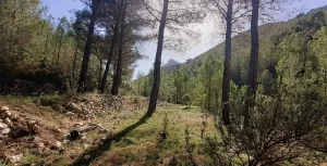
Once you reach the official path (at 1.8 km), there is a pretty forest area to pass through (a little relief if you need some shade!)
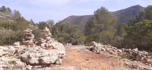
After a small ruin and some decorative cairns, the landscapeopens right up as you reach a big ruin (as well as some others hidden behind it in the shrubbery).
From this point, the remainder of the route is more-or-less flat, or downhill heading back towards Jalón.
This mountain hiking route returns along the far side of the mountain, staying on the right side (but far above) the Barranc de les Passules. This area is not so exposed to the sun, and really pretty, with lots of trees, and flatgrassy areas(great for relaxing in the shade), as well as some more ruins to explore.
To begin this mountain hiking route, cross the bridge, go to the bench, and climb over the wall at the corner. Go past the green bush and follow the fence up to a clearer path.
If you look from the dry riverbed upwards, you will see where the path goes up from there.
(Google Maps™ mapping service is a trademark of Google LLC and this blog is not endorsed by or affiliated with Google in any way)
Alternative options
Longer routes (Extra Road walking)
If you want to start this mountain hiking route from closer to Jalón town, there is a car park here, which would give you an extra 1.9 km walking on a (quiet) road.
This carpark can accommodate about 15 vehicles.
There is another (closer) car park here, (on Camí del Cementerí near Jalón) which would give you an extra 1.5 km walking on a (quiet) road.
This is a big car park and there are always spaces available.
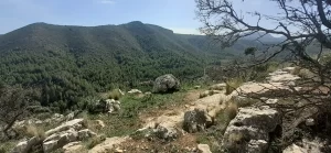
Grassy forest area on the way back from Serra de la Devesa
Watch out for mountain bikes on the return forest path because there are signs indicating that also an official mountain biking route. Although didn´t see any when I did this route on a Sunday in October
You cannot drive on Camí del Cementerí in Jalón between 8am-9.30am and 30pm-2.30pm on weekdays (due to school operations)
Rocky ridge up to Serra de la Devesa
The final mountain hiking route is the shortest route, but also the highest mountain. It is perfect for an add-on to Hike 2, but also for a beginner mountain hiker starting at Coll de Rates. Read on to find out more…
A short but satisfying mountain hiking route through the beautiful Barranc de les Passules, with a challenging ascent: steep with fossil-covered rocks and no visible path (plus a little scrambling if you want it). Followed by a more gradual and clearly defined descent, then an easier walk back around the side of the mountain.
View from Penya Talai summit
Route Summary
The Penya Talai mountain hiking route in Jalón consists of:
Distance: 5 km*
Time:2 hours*
Difficulty:Moderate
Type:Circular
Elevation: 322 metres
Alternative options: Shorter and longer routes possible
*There is an extra 0.2km shown on my route because I walked to the house on the way back hoping to get to the Barranc de les Passules from there. However, it is no longer possible.
*I took less time than stated here. However, I ran on the easier sections, so it would take a little longer to hike.
Large rocks surrounding the Penya Talai summit
Route Description
The first 1km of this mountain hiking route is on a nice path leading up through the Barranc de les Passules (canyon). The path is flat at first, but ends on quite a steep side-slope, forcing you to walk just above the path on the left, to ensure that you don´t slidedown into the canyon on the right-hand side.
However, if you want to add in some scrambling to this mountain hiking route (which I definitely recommend!), you will need to drop down into the Barranc de les Passules as you reach the bottom of the ridge here.
To hike up Penya Talai, once you reach the edge of the mountain, you will leave the path and go up to the right where there is no visible path.
From here you have 0.8km of relentless ascent: 212m up to Penya Talai.
The beginning part of this hill is mud-covered with some tufts of grass, but with lots of rocks scattered around.
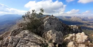
As you near the ridge, the terrain gets rockier, finally becoming an area of large rocks that you must clamber over in order to reach the Penya Talai peak.
Ridge scramble on Penya Talai
Fancy FLOATING DOWN a river on an INFLATABLE RAFT?
The path down Penya Talai is much shorter (only 0.4km) with just 125m to descend.
This path is rocky to begin with, but clearly indicated by cairns. It then passes a really pretty grass-covered area with a sprinkling of trees (great for a picnic), and down to the country road.
Follow the country road for 0.7km, until you reach an unfenced piece of land. Here you can return to the perimeter of the Penya Talai mountain and follow the smallgully back to the Barranc de les Passules and return on the same path back to the car.
If you plan on hiking with more people, then you can start here instead.
To begin this mountain hiking route, simply follow the path!
(Google Maps™ mapping service is a trademark of Google LLC and this blog is not endorsed by or affiliated with Google in any way)
Alternative options
Shorter route with more parking (from Coll de Rates)
Alternatively, you could park here and begin the hike from Coll de Rates.
This mountain hiking route could be done from Coll de Rates as a:
Circular route: 6km (by meeting and following my route)
Linear route: 2km (via the most direct route to the top)
The linear route would be a great option for people who are not used to doing challenging hikes, but want to give it a try!
Simply cross the road, follow the track, and you will soon meet the path.
Shorter route (Less country road)
Instead of veering right on the country road, you can continue straight aheadhere, and take a more direct route back, reducing the distance of this mountain hiking route by 320 metres.
View towards Penya Talai from Barranc de les Passules
TOP TIPS for this route
Stay on the higher path through the Barranc de les Passules (i.e. follow my return route on the way there too). I tried to find a lower path on the way there, but ended up having to climb up a wall to get back on track)
Look up from the Barranc de les Passules to see the scrambling potential
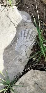
Look out for fossils on the way up. They are all over this side of the Penya Talai mountain and some are quite big!
Just before the peak, there is a cliff edge on the right with a big sloped rock at the top, so be careful if you have a dog!
Fossil on Penya Talai
Combine these hiking routes
It is possible to combine either 2 or 3 or these mountain hikinghikes, to create a longer and even more challenging route, so that you can really get a good workout!
Therefore, you could complete hike 1, then more or less return to the carpark on your way to begin hike 2, which you can then combine with hike 3.
This would result in the following mountain hiking route in Jalón:
Distance: 9 km
Time:8 hours
Difficulty: Difficult
Type:Circular
Embrace the adventure!
Want to explore more?
For other guided tours or help with your travel planning, check this out.
Where to stay
If you want to stay in the Jalón Valley, Costa Blanca, then I definately recommend these beautiful holiday homes.
Casa Sadie and Casita Muñeca are perfectly located in a tranquil area, surrounded by mountains and wild boars that roam the forest at night. It is great whether you want relaxation or adventure.
I have stayed here myself (in Finca Alegria) so you will find the hiking/runningroutes that I did locally here (there is a list called “Jalón”).
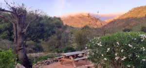
This was my view from the garden…
View from the holiday home in Jalón Valley (October 2024)
Where to eat
Looking for a unique immersive dining experience? Dine with hosts in their own home.