This site contains affiliate links, so I might receive a commission if you click and buy something. It doesn´t cost you any extra, but I could treat myself to some extra snacks to keep me going on my outdoor adventures! Read more in my Privacy Policy
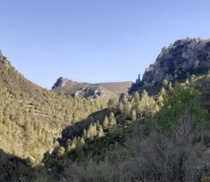
Barranco de la Encantada (or Barranc de léncantada in Valencian) means “Enchanted Ravine” and it certainly lives up to its name.
It is a narrow ravine about 11km long which passes through the municipality of Planes.
This article will cover a 5km stretch beginning near the Beniarrés reservoir.
In this section there are lots of interesting things for the adventurous to do and explore, such as a natural pool to cool off in the summer, caves to search for (if you are adventurous), hiking routes, and a cool place to watch the sunset or go wild camping.
Or you can visit one of the picnic areas, relax and enjoy the beautiful scenery, or pick blackberries (when they are in season)
There are two locations from which you can access this 5km section of the Barranco de la Encantada: from the north and from the south.
This article focuses on the northern part. However, you can read all about the southern part here, which also includes wild camping if you are feeling adventurous.
Looking for ESSENTIAL OUTDOOR GEAR for your mountain adventures?
Recommended gear for running:
GARMIN Forerunner 55 Running Smartwatch (Aqua)
Always-on colour display, quick-release and 2 week battery life
The Barranco de la Encantada is mainly for the more able and adventurous who want to swim or scramble and hike.
There are only really two accessible areas (suitable for wheelchairs or people with mobility issues)…
Want to go WILD SWIMMING in crystal-clear water?
To visit from the north, you must first drive towards the Beniarrés reservoir dam.
To the East of the dam there is a turn off with a brown sign indicating “barranc de l´Encantada” (Barranco de la Encandada). Follow this road to the end and turn right to enter the car park.
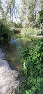
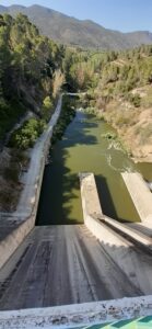
Just before turning right into the carpark, there is a footpath which continues straight ahead between the bushes and over a small bridge. Follow this path to the right and you will reach some running water which is fed from the Beniarrés reservoir.
I was chatting to some locals elsewhere in the Barranco de la Encantada, and they didn´t realise that this part of the water was accessible.
So, I took them there to show them, and we cooled off in the water.
In August 2024, the river was flowing and was about knee-deep.
The water appeared to be clean, but there was algae stuck to the rocks that came away when I entered. We saw some big fish feeding on the algae and jumping upstream over the rocks, like salmon (so it must be good!)
You definitely need beach/water shoes to enter here or it is very difficult to walk.
TOP TIP for Adventurers
You can walk through water here, and follow the river upstream.
I haven´t tried it (because I forgot my beach shoes, so I only went so far), but it might just be possible to follow the river all the way to the dam.
TOP TIP for Explorers:
You can cross to the other side of the water to get to the:
There are blackberries all around this area (when in season), but the best ones are next to the water!
This is the more well-known area for bathing in the northern part of the Barranco de la Encantada.
The locals just call it the Barranco de la Encantada, so for the purpose of distinguishing between the actual canyon, it is referred to as the natural pool (although there are other natural pools in the southern part of the Barranco de la Encantada).
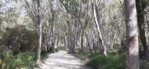
To access it from the car park, you pass the barrier and continue straight ahead until you see a path 90 degrees to your right (which runs along the right-hand side of the riverbed)
In summer 2023 there was an abundance of crystal-clear water (although it is never deep enough to actually swim in).
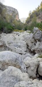
However, in August 2024 the water was shallow, stagnant and not even worth paddling your feet in (in fact, it looked so sad that I didn´t take a photo of it!)
This is where I met the locals who were very disappointed by th elack of water and showed me their photos from the previous year. So, we went to cool off in the Serpis river together instead.
Want to go WHITE WATER RAFTING down a crystal-clear river?
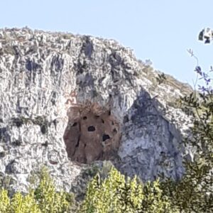
There are three caves that you can (potentially) visit…
This is a series of caves that you can see from the entrance to the Northern car park. Just look up towards the mountain.
When I first saw it, I assumed that it would be impossible to access since it is so high. However, I have since read that others have tried to go up there and got very close to accessing it (but not quite).
TOP TIP for Adventurers
If you like scrambling or climbing (and have some gear, such as a rope) I dare you to give it a try!
TOP TIP for Explorers:
On my hiking app, there is also a path leading to above the Cova dels Nou Forats.
However, the caves are far from the mountain top, and access from above looks risky!
But if you like exploring, maybe you could go and check it out!
The turnoff from the main road around the reservoir is here…
I had driven up this road when I was looking for somewhere to camp, but it is agricultural land and I didn´t have a view of the reservoir like I was hoping for, so I left.
It was only afterwards that I realised that it might lead to the Cova dels Nou Forats.
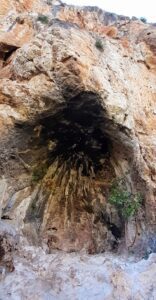
This is actually 2 caves next to each other half way up the mountainside. One you can enter, and the other is more exposed.
I found it (nameless) on my hiking app, and it doesn´t exist on a satnav/GPS.
However, there is a clear but un-signposted path leading off the main path and up the mountain.
This path becomes narrow and wild with some rocks and branches to scramble over, as the mountainside is completely covered in shrubbery.
Once on this path, you ascend/traverse for about 10 minutes before reaching the caves.
Recommended gear for hiking:
MAMMUT Outdoor Zip Off Pants
Durable, comfortable and fast-drying
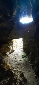
To reach this area, you must follow the path past the first caves, which is very wild (your legs will get scratched!)
This cave was also only shown (and named) on my hiking app.
It doesn´t exist on my satnav/GPS, and I couldn´t find it in real life!
The cave is allegedly behind the interesting erect rock formation sticking up out of the mountain to the right.
TOP TIP for adventurers
I did a nice bit of scrambling in this area, and I really wanted to continue searching for the cave and scrambling even higher. But I finally gave up because it was getting late and I had to go and find somewhere to camp before the sunset.
If you want to search for the cave, this is a possible location (check out the satellite view. Looks interesting, right? …
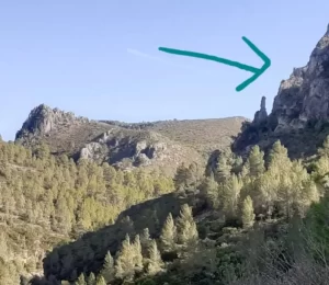
If you like scrambling I definitely recommend going there to see if you can scramble all the way to the top! I am positive that you can (there´s always a way)
You will have to walk through the wild in order to get over the top of the mountain Alt de Senabre.
I recommend that you stay on the ridge, with the Barranco de la Encantada always down to your left-hand side. Eventually you will meet the path leading you to Toll de L´Estret (you can read more about the Toll de L´Estret here).
This potential hiking/scrambling very appealing to me (because it is much more adventurous) .
However, if you are a little less adventurous, but like walking longer distances, then you will like the circular hike for adventurers
Love caves?
Check out these top-rated tours!! (the first two include transportation)…
There are two picnic areas, both potentially in walking distance…
Forn de calç
This picnic area is very close to the car park. To access it from from the park, just pass the barrier and continue straight ahead.
It is very small with just two picnic benches but it is situated in such a beautiful spot right on the edge of the forest next to an old building in good condition, with a great view.
I imagine that it would be even prettier if the Barranco de la Encantada was full of water!
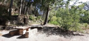
Área Recreativa de Beniarrés
This is also accessible on foot from this car park.
However, you would have to walk through the water of the Serpis river. In August 2024, the water was about knee deep, and the rocks were covered in algae and very slippery.
Another option is to drive there, which takes 10 minutes because it is not a direct route, and you can park in the dedicated car park…
There are 2 hiking routes that you could do from here:
Linear hike
This begins at the natural pool and ends a the Toll de l´Estret (you can read more about the Toll de L´Estret here). The terrain is rocky and it involves a little bit of easy scrambling (i.e. using your hands to manoeuvre over big rocks).
Circular route
It is possible to do a circular hike in order to visit all of these areas on foot (but your feet will get wet!)
The distance is about 15km which would take at least 4 hours (walking through the river bed could be slow due to the terrain).
It consists of:
Distance: 10km. Time: 2 hours 45 minutes
Distance: 5km. Time: 1 hour 15 minutes
(Google Maps™ mapping service is a trademark of Google LLC and this blog is not endorsed by or affiliated with Google in any way)
I didn´t do the hike in August because it was too hot, and I was hunting for places to swim, which were easily visited by parking at each end of the barranco (with just a 15-minute drive in-between).
This circular route of the Barranco de la Encantada is only suitable for adventurous hikers and trail runners because;
I suggest that you park at the northern car park and go and check the water levels of the natural pool and the River Serpis first to make sure that you are happy to pass through it. In August it was very shallow, but it could be deeper after more rain.
You cannot walk through the Toll de L´Estret, but just to the west you can bypass this part via some small paths (you can read more about the Toll de L´Estret here).
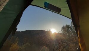
If you like wild camping in a tent or bivvy bag, or you want a nice place to watch the sunset, then there is a top secret location, high up above the Barranco de la Encantada, that is perfect for you to do this.
From the northern part of the Barranco de la Encantada, it is just a short drive there, and there is a dedicated parking area.
You can read all about it here.
PLANNING A VISIT to the Costa Blanca? Find everything you need here
THINGS TO PACK
Recommended supplement for post-exercise:
Magnesium-3 (Malate, Bisglycinate & Citrate)
For daytime energy, sleep and muscle recovery
There is no need to book or pay. These places are wild. Be free!
There are no facilities here (only the car park, and the picnic benches/tables in the designated areas)
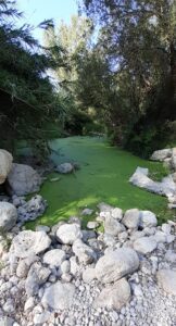
If you want to go wild swimming, then summer is usually the best time to cool off in the hot temperatures. The beginning of the summer (from June) is better before the water dries out too much.
Many people wait until August, when it is hotter and they are desperate to cool off, but it is too late to make the most out of the water here.
I visited on a Sunday in August 2024, and there was a constant stream of people with the sole purpose of swimming in Gorg del Salt.
However, I recommend that you avoid the summer months if you want to the longer hike and just see the beautiful sights on your way.
In Spain, temperatures are still quite high in late Spring or early Autumm. Therefore, if you want to hike at this time, I recommend that you set off early in the morning or late in the afternoon.
The 5km hike along the Barranco de la Encantada can be more shaded, but the longer circular route is quite exposed to the sun.
Enjoy!
Why not buy me a coffee
to keep me going on my adventures
so that I can share them with you!
Wild Child Costa Blanca
