This site contains affiliate links, so I might receive a commission if you click and buy something. It doesn´t cost you any extra, but I could treat myself to some extra snacks to keep me going on my outdoor adventures! Read more in my Privacy Policy
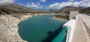
The Embalse Amadorio (Amadorio reservoir) is situated inland, just north of Villajoyosa and is less known compared to other reservoirs.
There is something for everyone here if you enjoy spending time outdoors away from the crowds.
For the adventurous you can: cycle, hike, run, paddleboard, kayak, or wild camp (in a tent or campervan)
Or if you prefer to relax you can simply visit to sit and enjoy the views.
There is more difficult terrain to ascend/descend, with mountains, ´beaches´ and forest to explore.
But there are also flat and open “accessible” areas, where people in a wheelchair or those with mobility issues can enjoy the area too.
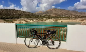
Exploring the Embalse Amadorio on a bike is great because you can travel all the way around it (this cannot be done by car, and walking on the main road would not be fun on foot).
This article initially focuses on the road cycling route, because that is what I did (recording the route on Wikiloc, so that you can follow it too).
However, it also incorporates the other outdoor activities which I investigated enroute.
Looking for ESSENTIAL OUTDOOR GEAR for your mountain adventures?
There are 7 ways that you can explore the Embalse Amadorio (Amadorio Reservoir) that are included in this article…
Want to visit the charming medieval town of Guadalest overlooking the reservoir with transportation from 3 locations?
This cycling route goes around the “Embalse del Amadorio” (the Amadorio reservoir) (Do not use this link for directions).
The route is circular and I did it in a clockwise direction. I recommend that you do this too, so that the main road part is downhill and you can enjoy the incredible view on the way down.
Summary:
Recommended gear for cycling:
SHIMANO RC100 Cycling Shoes (unisex)
3 colours available
There are three types of terrain on this road bike route around the Embalse Amadorio:
I did this route on a road bike, since it is predominantly on roads.
My road bike has tough tyres and I often take it on very easy mountain biking routes (i.e. gravel/sandy tracks).
However, when I reached the “rough track” I had to push my bike up the rocky and uneven path.
Regarding the terrain:
I did it on a Sunday in September, and there was very little traffic.
(even if you push your bike up the track, like I did)
Prefer HIKING alongside a river in a CANYON and seeing a BEAUTIFUL WATERFALL not far from Alicante city?
There is very little shade on this route around the Embalse Amadorio.
Although there are two tunnels, they are both very short.
I started the route at midday when the sun is high in the sky and apart from the odd bit of shade from a few trees near the side of road, I was cycling in the sun.
Therefore, I recommend that you:
Also,
There is an official car park near the Embalse Amadorio dam although I parked just at the bottom of the carpark´s hill, close to the tunnel instead.
There is an unofficial parking which is at the other side of the dam.
Here there is a barrier blocking vehicular access to the reservoir, with a gravel area that can accommodate a few cars.
In fact, many people arrive here unintentionally because if you are driving from the north/west, and you enter the name of the reservoir into your satnav/GPS it may direct you to here.
There are also some other parking spots, which are useful for specific activities (such as hiking, camping in a van, or “accessible” routes) that are included in the relevant sections below.
The route around the Embalse Amadorio begins at the dam…
Dam
From the tunnel entrance you can:
I recommend that you take the first option because it gives you the best view of that side of the dam,
When you cross the dam make sure you stop at various points to look down where you see lots of turtles swimming in the water!
Tunnel
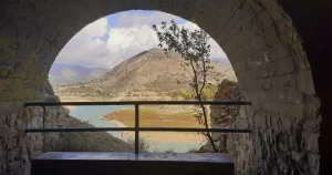
In the tunnel, make sure you stop to look through the ´windows´. There is also a bench where you can stop and enjoy the view in the shade.
Prefer CLIFF JUMPING into CRYSTAL-CLEAR WATER?
Quiet road
The first part of the quiet road has no traffic because there is a barrier here preventing vehicles from accessing the tunnel and the dam.
The second part of the quiet road has almost no traffic because the only vehicles entering are people who want to visit the Embalse Amadorio.
Big ruin
You can take a detour up a rough track to the right, which will lead you to an old ruin.
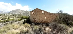
This is the most difficult terrain, and it is obviously optional.
However, it is worth it to see the view. From up there you can see the reservoir and dam, as well as Villajoyosa and the sea in the background. It would be a great place to watch the sunrise!
Ups and downs
After the ruin, the rest of the quiet road has quite a few ups and downs (ascents and descents) compared to the rest of the route.
Warning! There is one particular steep descent which immediately becomes a steep ascent. However, it is dangerous to try and build up any speed for getting up the hill (especially on a road bike) because the lowest point of the road is also a slight curve that is covered in sand and pebbles that could cause your tyres to slip.
Small ruin
TOP TIP for Explorers:
There is a small ruin here that I didn´t stop to look in.
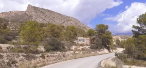
Detour to the old bridge
TOP TIP for Explorers: There is a detour that I didn´t take but I wish I had! (at the time I couldn´t see where it led, but later I saw it from the viewpoint).
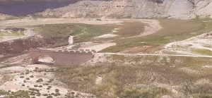
If you turn off here there is a wide flat track that leads you to a collapsed bridge that used to cross the river. I have no idea when this happened (probably many years ago) but it is a shame, because it would be great to be able to access that part of the water, which currently is like a ´beach´.
In September 2024, the part of the river bed which the collapsed bridge reaches was dried out. It still looks pretty cool regardless.
Arch bridges
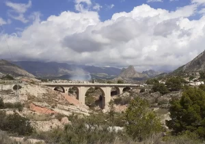
At the opposite end of the Embalse Amadorio there are two bridges…
First you will pass a “Pont d’Orxeta, embassament d’Amadòrio” which is a small 1-arch bridge (Pont” means bridge in Valencian).
Then you will pass a large 5-arch bridge which doesn´t seem to have a name (and behind you can see the town or Orxeta (in my photo there is smoke because a firecracker display had just finished in the town at that time).
Main road
The main road has some traffic, but not a lot. It is largely downhill and the views is great!
Warning! There is one bend to the left where vehicles might not see you straight away, so stay to the right-hand side here.
So make sure you get travel insurance while adventuring in Spain, in case you have an accident on the road.
Viewpoint
There is an official viewpoint (“Mirador del Riu Amadòrio”) just off the main road, where you can look down on the Embalse Amadorio.
Warning! Cars and motorbikes also pull in/out of this area. In fact, people often stop here last-minute because they didn´t realise that the viewpoint existed until they were approaching it.
Recommended gear for training:
Spinning Exercise bike
Super silent, smooth to ride and easily adjustable
Main road turn off
On my route, I turned off the main road here which is a gravel car park called “Sortida Passejada per a Gossos” (although it is not signposted).
This is a pleasant easy track that is very close to the water with stunning views.
However, you might want to avoid this route due to the ´last hurdle´…
If you want to avoid it, simply continue on the main road and take the first turning on the right, which will lead you back to the official car park.
The ´last hurdle´
Right at the end of the route (when you reach the end of the track) you need to:
There are also other access points between the beginning/end, where you can access to/from the road on a mountain bike. These are the same as the hiking paths.
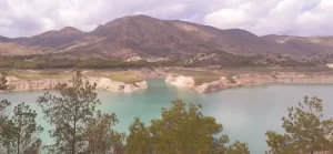
You can do some easy-moderate hiking at the Embalse Amadorio in the area between the upper quiet road (just after the tunnel) and the reservoir.
Warning! This is also a mountain biking area, so there are some ´ramps´ in the path, as well as mountain bikers.
There are various access points, but I recommend these ones:
If you like hiking and cycling and you want to combine the two activities into one adventure, there is a great Coastline e-bike and hiking guided tour that you can do from Alicante city to the beautiful Cabo de Huertas.
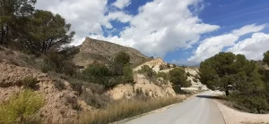
There are two areas where you can do mountain hiking around the Embalse Amadorio…
Mountain hiking area (east)
From the unofficial parking, there is a track leading up the mountain
You can do a short circular route by hiking up to this point and then returning to the road via an old track
1.5km
There are also some longer circular hiking routes up in this area.
I recommend that you incorporate both of these areas (high and low) into one hike in order to experience a little bit of everything!
Mountain hiking area (north-east)
If you want to stay away from the crowds there is a rarely used car park, from where you can hike up to this nameless mountain and beyond.
The hiking path begins here.
Would you like to explore the mountains of Villajoyosa on a horse?
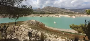
If you want to have a (lightweight) ´beach day´ relaxing on the shore of a reservoir, then there are at least three suitable areas around the Embalse Amadorio…
.
I say “lightweight” because none of these options are very close to the road, so I recommend packing your things in a backpack (definitely no trolley filled with beach furniture!)
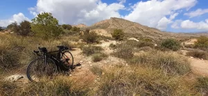
Mountain wild camping
If you like wild camping higher up, you could camp near the big ruin.
There is a big open space at the top of the track, but you can definitely find more hidden spots (for a small tent) further away from the ruin between the tufts of grass.
Want to WILD CAMPING high above a canyon?
Private camping
If you want to park in a spot that just accommodates one vehicle and has a view of the reservoir, you can park here. There are two spaces very close to each other, but only the second space has a view of the Embalse Amadorio.
Car park camping
You could also camp in the official car park for a great view, but you may have less privacy and peace.
When I visited early-September, there was a sole campervan and the couple almost had the area to themselves.
A few cars came and went, but they all parked in the lower area (like I did), just to walk along the dam, and then go home. Most of them didn’t even visit the upper official car parking area
Recommended gear for camping:
Ultralight camping/travel blanket
Warm and waterproof
6 awesome designs available!!
Make HOLIDAY PLANNING easier with handpicked GUIDED TOURS allowing you to explore the Costa Blanca?
I have seen people paddleboarding/kayaking in the Embalse Amadorio several times, thought usually just one person at a time.
However, I have never seen anyone actually entering/leaving the water.
In September 2024 the water level was very low, so you would have to walk some distance wherever you decide to enter!
In most places it is impossible to get close to the water with a vehicle.
However, I found two locations where it would be easier to access the reservoir…
Warning! Make sure you enter the water away from the dam, on the other side of the row of yellow buoys
If you prefer to go on a guided kayaking tour there is an awesome Kayaking trip that you can do from Cala Granadella in Jávea, which involves crystal-clear water, beautiful calas and a visit to a cave.
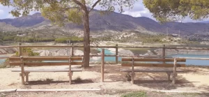
There are four “accessible” areas that I would recommend…
If you simply want to drive and look at the Embalse Amadorio from a high point, then there is a viewpoint on the main road. This is a great place to watch the sunset!
If you drive up to the official car park there are 9 benches (no tables) on the same level with view of the reservoir (and 1 bench in the forest if you need some shade).
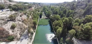
From here there is an accessible path leading to the “Arcos de Presa de Amadorio” (old dam arches) When you reach them there are two benches where you can rest.
You can park at the “Sortida Passejada per a Gossos”
This is a car park is for dog walkers, although it isn´t actually signposted with the name or purpose. From here you can follow the road all the way to the dam, and it becomes very pretty with a fairly close view of the reservoir.
1.5km of easy track (flat with sand/pebbles)
Of if you want a shorter journey, you could drive right to the end of the road and park here to travel in the other direction.
Although this location is directly below the official car park, you can only access it from here by walking up lots of steps.
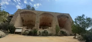
You can park here and follow a long flat track towards the reservoir.
This leads to a bridge, with unofficial ´benches´ to sit on when you reach it.
500 metres of easy track (flat with sand/pebbles)
I didn´t explore this path on my bike when I visited because I couldn´t see where it led until later…
If you visit the viewpoint, you can see the broken bridge from there!
In September 2024, there wasn´t any water in this area. It will be a much nicer route when there is!
Want to visit BEAUTIFUL WATERFALLS and SWIM, or HAVE A PICNIC near Navarrés?
There are lots of places that you could hike to and lay down a picnic blanket.
However, there are no official picnic areas, and no picnic benches (no tables) anywhere around the Embalse Amadorio.
So, if you want to have an “accessible” seated picnic then you will need to take a table and chairs with you.
This would be suitable to do at the official car park.
“Antigua Fábrica De Ladrillos”
If you want to explore more around the Embalse Amadorio, yo could park in the dog walkers´car park and walk to the old brick factory.
I had planned to check this out after my cycle, but simply forgot! However, it looks like an interesting place so why not go and check it out!
If you are in the city (Alicante or Valencia) and you don´t have a car, then these day trips including transportation are perfect for you:
Why not buy me a coffee
to keep me going on my adventures
so that I can share them with you!
Wild Child Costa Blanca
