This site contains affiliate links, so I might receive a commission if you click and buy something. It doesn´t cost you any extra, but I could treat myself to some extra snacks to keep me going on my outdoor adventures! Read more in my Privacy Policy
The Catedral del Senderismo (“The cathedral of hiking”) is a classic hiking route that passes through the Vall de Laguar municipality located in the Marina Alta area.
It is also named the Barranc de l Infern (PR-CV 147) because it crosses the barranco twice, in a more or less circular shape.
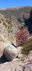
The Barranc de l Infern (“Hell Canyon”) is valued for its geological and botanical features, as well as being knows for the Salt de Fleix (Fleix waterfall).
It is also famous for having 6,000 steps(according to one source, or 6,800 steps according to another), which were crafted by the Moors many years ago.
However, if you a person who likes to count steps with a fitness tracker, then I counted 30,201 steps from start to finish!
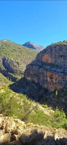
The Catedral del Senderismo is a mostly easy-to-follow route with magnificent views of the Barranc de l´Infern canyon, cliffs, and surrounding scenery.
However, there is alot of elevation, so the hike can be physically demanding. The Catedral del Senderismo is largely made up of hills, consisting of 3 ascents and 4 descents. Starting from Fleix, the route will…
The Catedral del Senderismo route is home to the Salt de Fleix, leading down into a stretch of ravine with that is the most emblematic part of the Barranc de l´Infern.
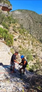
Hikers will cross this area at El forat. However, for the more adventurous, it is a popular place for various dry and wet canyoning (Barranquismo) routes (requiring technical equipment and skills, or with a guide) which could include a rappel down this 60-metre high waterfall, into deep wells and down natural slides.
Recommended gear for running:
GARMIN Forerunner 55 Running Smartwatch (Aqua)
Always-on colour display, quick-release and 2 week battery life
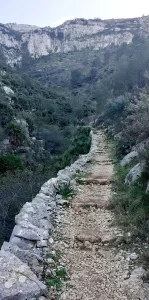
This Catedral del Senderismo (Barranco de l´Infern) hiking route is known for its 6,000 “steps”.
However, they are not the flat-surfaced steps that you might imagine.
The edges of the steps are made up of various shaped rocks, which are not necessarily horizontally positioned, and they vary in depth and height. They are typical of a stepped mountain path.
As soon as you access the “steps” here, you will immediately see what the terrain is going to be like.
The route is not 100% steps, however. There are easier sections of narrow earth paths, very short sections of rocky river bed, and some concrete pavements and country roads.
Zigzag path leading down to the Girona River
Who is it suitable for?
The Catedral del Senderismo (Barranc de l´Infern) route is suitablefor:
It is better to avoid the Catedral del Senderismo (Barranco de l´Infern) hiking route in the summer months, because the high elevation makes this an already demanding route, which could be dangerous with high temperatures.
The official advice is to avoid doing this route during or after a period of heavy rain because there is a chance that the canyon could become flooded. El Forat
However, I did this route after one night of heavy rain, and it was fine.
In fact, it was better after a little rain, because the natural springs, canyon pools, and old washhouse were all full of shimmering crystal-clear water.
Where to park
To do the Catedral del Senderismo (Barranco de l´Infern) hiking route, you can park here.
(Google Maps™ mapping service is a trademark of Google LLC and this blog is not endorsed by or affiliated with Google in any way)
However, it is also possible to begin the Catedral del Senderismo (Barranco de l´Infern) hiking route hereat Pla De L´avenc. Pla De L´avenc , which may be useful if you are travelling from the north-west of Vall de Laguar, and don´t want to drive so far.
My hiking route
You can follow my hiking route for the Catedral del Senderismo (Barranco de l´Infern) here.
The official theoretical time is 5 hours, and I took longer than that. However, I stopped a few times (e.g. to help somebody that was lost, and simply to have a little sunbathe at a nice resting point). So, 5 hours is a more accurate time
Where to hike
To begin the Catedral del Senderismo(Barranco de l´Infern) hiking route simply exit the car park, cross the road on the zebra crossing, turn left and follow the path off the main road.
Route Description
Just before the official starting point of the Catedral del Senderismo (Barranco de l´Infern) hiking route steps, you will pass a natural spring and washhouse…
Lavadero de la Font Grossa
Here on the right you will find an old washhouse called the “Lavadero de la Font Grossa”, because it is fed from the “Font Grossa” natural spring opposite.
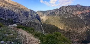
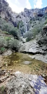
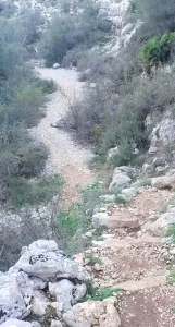
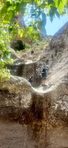
As begin to see downinto the canyon below, the path will pass the top of the Salt de Fleix (Fleix waterfall)
From here, you will begin to see the zigzag path leading down into the canyon.
The waterfall itself only appears after it has rained a lot, which hasn´t really happened for a couple of years.
However, I have seen videos, and it really is spectacular if you can catch it at the right time.
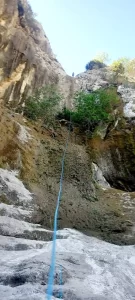
Salt de Fleix is 60-metres high, and is a popular canyoning (Barranquismo) route, which adventurers can rappel down to kick off an adventure that continues even further down into the canyon.
Just after this point there is a fixed chain on the left side of the path, which you can hold on to, to avoid slipping on the section of sloped rock.
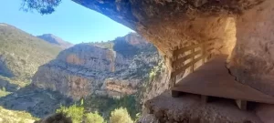
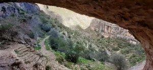
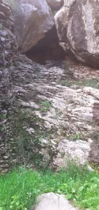
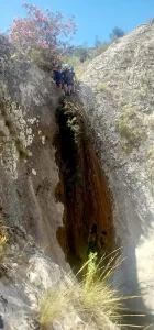
Go towards the rocks on the right, and step through them, heading towards the rock and you will see the iconic scene that this Catedral del Senderismo route is famous for…
View from the arch
Arch, cave and footbridge
As you reach the rock you will be welcomed into the canyon through an archway, suddenly providing you with an incredible view.
The wooden footbridge is your red carpet as you enter into the big cave that is your throne, as you admire the magnificent kingdom below.
From here, you can see the beginning of the Catedral del Senderismo steps leading down to El Forat and beyond.
TOP TIP for Adventurers:
You can climb up into the upper part of the cave for an even better view.
This is the section of the Catedral del Senderismo hiking route that could potentially be “flooded” or difficult/dangerous to cross following a period of heavy rain. Luckily it is very close to the beginning of the route, so you will discover very quickly whether it is an issue or not.
After one night of heavy rain, a lovely pool of water had accumulated just above the path, making for a very pretty picture with the towering waterfall backdrop.
From El Forat, you will follow the path that turns towards the north, passing some impressive rock formations before leading you down to the first descent, the Riu Girona…
El Forat pool with Salt de Fleix in the background
Riu Girona (Girona River)
The Riu Girona (actually part of the Barranc de l´Infern) is a very wide, flatriver bed that is almost always dry.
It consists of a bed of smooth white rocks, which you will walk straight across (easily) as part of the route.
From the Riu Girona, you will begin to ascend the steps, passing a couple of “caves” very close to each other, with a small stream that runs behind the second cave (if it has been raining).
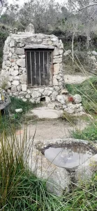
Pou Jubees D’enmig (old well)
The Pou Jubees D’enmig (or Pou de la Juvea) is an old well with a stone structure built over it. There is a metal gate, which can be opened if you want a closer look inside.
Water is also captured in a couple of small stone basins. Good if you have a dog with you!
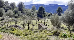
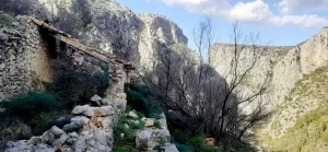
From Pou Jubees D´enmig, there is a gradually inclining country road where you will pass an old house on the right, and stepped farmland on the left.
Pou Jubees d´Enmig
Jubees d´Enmig (first peak on the Catedral del Senderismo hiking route)
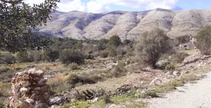
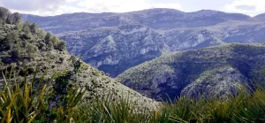
As you reach the top of the road, you are rewarded with a fantastic view of the Sierra de la Carrasca, the large rolling mountains spread out ahead of you, taking up the entire width of the landscape, with the farmland nestled in the valley below.
This is the first “peak” on the route, and you will follow the road to descend from here.
Jubees d´Enmig
TOP TIP for Explorers:
There is an unofficial path leading up to the forest-covered hill on the left hand-side, if you want to add a little extra to the route.
After the first peak, follow the road and signs.
You will pass a house on the left, turn left at the noticeboard, and then reach another house, which is an area called Pla De L´avenc…
Pla De L´avenc
Pla De L´avenc hiking area is an alternative starting point and parking area, which can accommodate at least 10 vehicles.
It would be suitable for anybody driving from La Vall d´Ebo or further north-west of the Vall de Laguar area, since it is closer than Fleix.
From Pla De L´avenc, the route goes between the trees, indicated by floor signs (pointing towards “Barranc de l´Infern” and “Font de Reinos”), as well as the yellow and white painted tree and wooden post.
Pla De L´avenc
Resting point
This path will lead you back out into the open farmland.
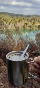
If you want to enjoy a little snack break before the steep descent begins, I recommend resting here. It is a lovely sun spot with a great view!
As you round the corner, the path becomes steeper and rockier (temporarily), passing some funky-shaped limestone rock on the right.
The beginning of the descent after Pla De L´avenc
Recommended gear for colder weather:
SAGUARO Barefoot Boots (unisex)
Water resistant with wide toe, rubber sole and fur lining
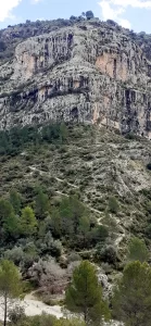
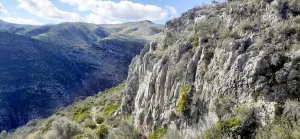
The path becomes fairly horizontal with some very large rocks that you can climb up on along the way, and an interesting cliff wall to admire on your right.
Beginning of the rocky cliff side walk
As you reach the second big rock, make sure you veer right through the bushes to stay on the horizontal path (not down!)
TOP TIP for Adventurers:
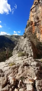
As you reach a more exposed rock on the edge of the path, there is some opportunity for adventure on the right-hand side if you fancy giving this little ridge a scramble…
(Google Maps™ mapping service is a trademark of Google LLC and this blog is not endorsed by or affiliated with Google in any way)
As you walk this horizontal path, take a look at the mountain side on the other side of the canyon. From here you can see the next ascent leading up from the Barranc de l´Infern below! It begins far on the right as a zigzag path, traverses left on a flatter path (which is less visible), and then zigzags up again diagonally to the left where it reaches a col-like gap in the mountains.
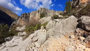
At the end of this flat section, a cairn indicates a steeper descent down to the next natural spring…
Cairn at the end of cliff side walk
TOP TIP for Explorers:
Just before the Font de Reinos, look out to the left. There is an overgrown, stone water storage pool, and what appears to be a path leading to the left. Go and see what you can find!
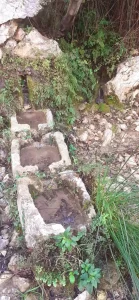
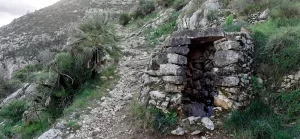
Font de Reinos (natural spring)
The Font de Reinos is a charming natural spring with water that collects in troughs.
Warning!
When I did this route after a night of heavy rain, the troughs were full, and there was water flowing from the wall. This caused the rocky path below it to be wet and muddy.
Font de Reinos
Soon you will reach the second descent, the Barranc de l´Infern…
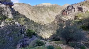
Barranc de l´Infern (“Hell Canyon”)
As you reach the Barranc de l´Infern (rocky river bed), turn right, and stay on the left-hand side of the river bed.
There is a cave on the left, just before you reach the path, which you can climb up into.
Warning!
The entrance can be wet and very slippery after some rain.
To begin the second ascent, there is a path heading up at the big rocks on the left.
Look out for the yellow and white paint on the big rocks, as well as the cairn, as the path is less obvious here.
Cave inthe Barranc de l´Infern river bed
Mirador (viewing point)
You will reach a path, which appears to go to the right.
This is not the route, but a viewing point reminding you to turn around and enjoy the wonderful view of the Catedral del Senderismo.
This is where I bumped into a lady called Laura who was doing the hike by just following the signs, and who was afraid that she was lost!
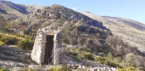
The path will flatten for a while, giving you a little relief, as you approach an old well…
Ruin near Mallada del Pou
Mallada del Pou
Here you will find a ruin, which used to be a corral/pen for livestock.
Close to it is an old well called Mallada del Pou (also known as Aljibe Morisco).
Mallada del Pou
Jubees de Dalt (the second peak on the Catedral del Senderismo hiking route)
At the top of this mountain, the path turns into a wide track, leading to Pou Jubees de Dalt, which is another old well situated at the summit.
Pou bees de Dalt
Pou Jubees de Dalt is another old well situated at the summit of Jubees de Dalt.
Pou Jubees de Dalt
From here, you follow the sign (Benimaurell 3.9km) down to the third descent…
Barranc de Racons (“Racons canyon”)
This involves crossing Barranc de Racons (or Barranco del Tuerto on Wikiloc), which is just a small section of narrow rocky river bed, before returning to the steps.
Barranc de Racons
The path gradually inclines here. I took advantage and had a little jog along this part.
The final peak on the Catedral del Senderismo hiking route
After more zigzagging up steps, you reach the final ascent, where you will see the sea and begin to hear civilisation again from the houses. After 5 minutes of easy walking, you will reach the quiet road. It is easy walking, and all downhill, from now on.
Path after the Barranc de Racons - the final ascent!
Font dels Olbis
Font dels Olbis is a natural spring and picnic area with just 1 round table, right next to the road.
Benimaurell
The Catedral de Senderismo routes passes through the town of Benimaurell, which has a couple of bars. There is also a carparkhere, right next to the bar with a big terrace and fantastic view!
After the second bar, you leave the town to see the last two water features…
Font de Benimaurell
Font de Benimaurell is a natural spring and picnic area with two rectangle picnic benches.
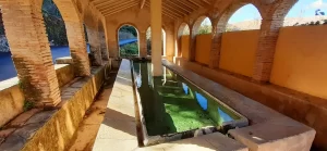
Lavadero la Font de Benimaurell
The Lavadero la Font de Benimaurell is an old washhouse, just downhill from the natural spring, before following this road all the way back.
If you are feeling adventurous, and want to explore parts of the Barranc de l´Infern that you cannot access on foot, then check out this Barranquismo activity: